Wishbone Property

Wishbone is 100% owned by Origen and is located in the prolific Golden Triangle in northern British Columbia, adjacent to the Galore Creek project jointly owned by Teck Resources and Newmont Gold. Covering 3,941 hectares, Wishbone has 11 target areas covering significantly high-grade gold-silver quartz-carbonate as well as volcanogenic massive sulphide-style mineralization. Rock samples of up to 6700 g/t silver and 202.2 g/t gold in samples of float have been sampled at several targets over 10km.
During recent field work company geologists noted rapid retreat of the central glacier and exposure of significant new ground. Results from boulders found along the southern edge of the central glacier have returned 202.6 ppm gold in an area that was previously characterized as a primary silver rich zone. Separate samples collected from boulders from this area contained up to 109 ppm silver and 1.2% copper. This sample is compared to the 175.5 ppm gold sample collected from a glacial boulder on the northern edge of the same glacier in 2021.

The Windy Showing
In 2024 and 2025 Origen field crews completed soil/talus sampling and an IP survey at the Windy target. 209 soil and talus samples were collected south of the Windy target area and a remarkably broad, anomalous gold in soil/talus anomaly was outlined and now extends greater than 1.5 kilometres over the eastward facing slope of the valley. The IP Survey tested the known gold-silver vein mineralization at the Windy target and extended 700 m further SW to explore the extensive Au-in-soil anomaly. Two Au-bearing veins show distinct responses. North Main Vein corresponds to a resistivity high while the Main Vein corresponds to a distinct resistivity low with high chargeability.

Drilling
Seven gold mineralized quartz-sulphide veins were uncovered by Teck in 1986 within a small 400 x 500 metre area. The Main Vein was traced for 500 metres in length and is apparently getting wider to the east where depth of overburden precluded exposure by hand trenching. Surface sampling returned 7.8 g/t Au over 3.3m, including 19.1 g/t Au over 1.6m, chip samples at the eastern end of the Main Vein
Nine drill holes tested the central area of the exposed veins with all the holes reporting notable intersections of gold mineralization:
| Hole | From | To | Width | Gold | ||
| (m) | (m) | (m) | (g/t) | |||
| BJ88-01 | 58.0 | 61.2 | 3.2 | 3.1 | North Camp Vein | |
| BJ88-02 | 36.9 | 38.4 | 1.5 | 2.7 | Camp and North Camp Vein | |
| BJ88-02 | 151.7 | 153.4 | 1.7 | 3.8 | Camp and North Camp Vein | |
| BJ88-02 | 166.6 | 173.6 | 7.0 | 1.6 | Camp and North Camp Vein | |
| BJ88-02 | 176.8 | 181.2 | 7.7 | 3.2 | Camp and North Camp Vein | |
| BJ88-03 | 60.7 | 61.2 | 0.5 | 3.7 | North Camp Vein | |
| BJ88-04 | 83.1 | 84.4 | 1.3 | 1.5 | North Camp Vein | |
| BJ88-05 | 98.6 | 99.0 | 0.4 | 10.5 | Main and North Main Vein | |
| BJ88-06 | 134.1 | 138.3 | 4.2 | 2.6 | Main and North Main Vein | |
| BJ88-06 | 142.8 | 148.2 | 5.4 | 1.4 | Main and North Main Vein | |
| BJ88-07 | 148.9 | 150.8 | 1.9 | 1.7 | North Main Vein | |
| BJ88-08 | 87.1 | 87.5 | 0.3 | 9.4 | North Main Vein | |
| BJ88-08 | 207.0 | 216.0 | 9.0 | 1.0 | North Main Vein | |
| BJ88-09 | 99.4 | 100.8 | 1.4 | 2.3 | ||
Table – Assay results from the 1988 Teck drilling: nine (9) holes totalling 1,353.2m to test the down dip extent of the gold bearing quartz veins uncovered in the 1987 exploration program. All the drill holes intersected notable gold bearing mineralization with the latter portion of hole BJ88-02 providing the longest mineralized widths in a silicified breccia zone.
Soil Sampling
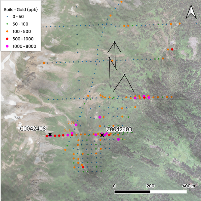
Two phases of soil sampling from 1982 onwards on the Windy prospect have shown remarkably high gold anomalies. 2023 field work aimed to partially groundtruth two of the anomalies. Two B horizon soil samples resulted in 1 ppm gold and 8.5 ppm gold. To date no bedrock source for these has been found – the areas south and east of the main showings remain largely unexplored.
